Sanu Fm
Type Locality and Naming
OUTCROP. Sanu village with type section exposed in Pariwar Hill located west of village Pariwar. [Original Publication: Dasgupta, S.K., Dhar C.L. and Mehta V.K. 1973. Progress report in Western Rajasthan Shelf, ONGC report (unpublished)]. The formation was first designated by Dasgupta et al. (1973) after village Sanu with type section at Pariwar hill, in the west of Pariwar village. Reference well: Interval 79-1008m in well Kharatar and interval 1340-2020m in well Lang-2.
Synonyms: Narayanan et al., (1961) described this litho-unit as “Upper Habur Bed” which was later on disagreed by Willm (1964) and Dasgupta et al (1973). Willm (1964) included it in Pariwar Fm. Dasgupta et al (ibid) opined that the “Pariwar Formation” of Willm (1964) and Upper Habur beds of Narayanan et al (ibid) can be better described as Sanu Formation of Paleocene age. Singh (1984) subdivided this formation (in subsurface) into two members, namely, Mohammad Dhani Sandstone Member and Kharatar Marl Member with definite local localities.
Lithology and Thickness
Sandstone and marl. The formation is composed of reddish unconsolidated, current bedded, glauconitic sandstone. A maximum thickness of 20 m has been reported by Dasgupta et al. (1973) around Pariwar village. In subsurface it is 670 m in Shahgarh sub-basin. There is a general reduction in thickness towards the eastern part of the basin.
The formation is composed in the reference well Kharatar-1 is divisible into
(a) Mohammad Dhani Member (Sandstone) comprising medium- to coarse-grained sandstone, friable, clean and moderately sorted. The basal part of the sandstone is argillaceous with layers of chocolate brown clay. Lignite streaks and grey shale also characterize the upper part of the unit
(b) Kharatar Member (Marl) comprises greenish grey fine to coarse-grained argillaceous feebly calcareous sandstone. It is overlain by clayey, light greenish grey, glauconitic limestone intercalated with marl. The upper part comprises of dark grey to black fissile shale and sandstone interbeds. The sandstone is light grey, medium- to coarse-grained with streak of lignite. The top of the member is marked by chocolate brown silty shale/ clay. The formation in the outcrop is devoid of microfauna. In the subsurface, limestone and marl in the upper part is rich in foraminifera and ostracods. Sigal et al (1971), Singh (1976.1984) and Singh and Sharma (1990) and Bhandari (1992,1995 and 1996) have reported a rich foraminiferal and ostracod assemblage, respectively, from the Kharatar Member.
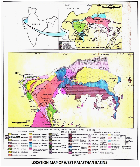
[Figure 1: Location map of West Rajasthan Basins (after Pandey and Dave, 1998)]
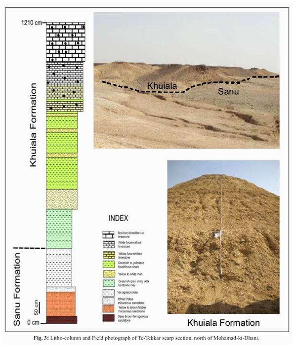
[Figure 2: Lithocolumn and Field Photograph of Te-Tekkar Scarp Section, Facies Analysis, Reservoir Characterization and Depositional Environment study of Hydrocarbon bearing Tertiary Sequences in Jaisalmer Basin, Rajasthan (after R. Pandey et.al., 2019) ONGC Bulletin, Vol. 54, No.1)]
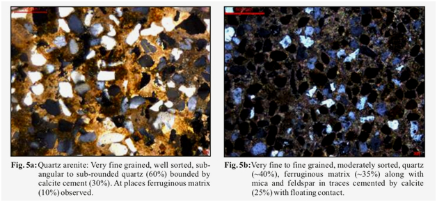
[Figure 3: Lithofacies of Sanu Fm, Facies Analysis, Reservoir Characterization and Depositional Environment study of Hydrocarbon bearing Tertiary Sequences in Jaisalmer Basin, Rajasthan (after R. Pandey et.al., 2019), ONGC Bulletin, Vol. 54, No.1)]
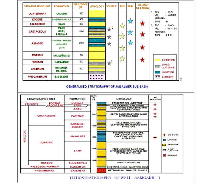
[Figure 4: Generalized and Subsurface Stratigraphy of Jaisalmer Basin (from dghindia.gov.in)]
Relationships and Distribution
Lower contact
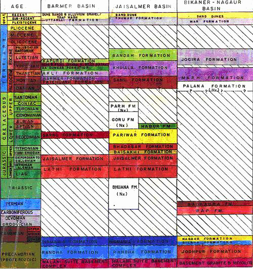
The lower boundary is a major unconformity. The formation overlies Pariwar Fm in north-eastern areas and in south-western part it overlies Habur Fm. In subsurface, it overlies Parh Fm in basinward areas and Goru Fm in shoreward areas.
Upper contact
The upper boundary is conformable with overlying Khuiala Fm in subsurface and in the outcrops it is unconformable.
GeoJSON
Fossils
The characteristic foraminifera include, Planororalities pseudomenardii, Morozovella velascoensis, P. pusilla pusilla, P. chapmani, P. compressa, M. angulata, Discocyclina seunesi, D. ranikotensis, Assilina dandotica and Miscellanea miscella. The characteristic ostracodes include: Acanthocythereis retispinata, Brachycythere rajasthanensis, Hermanites crecens, Protobuntonia ghotaruensis, Macrocypris guhai, Acanthocythereis procapsus, Cytherelloides jaisalmerensis, phalcocytehre improcera, Anommatocythere indica and Echinocythereis context.
Age
Depositional setting
The basal part of Sanu Formation is inferred to have been been deposited under continental environment with little marine influence. The limestone with glauconitic sandstone with intercalated shale in the upper part has yielded planktic and benthic foraminifers indicative of middle shelf conditions.
Additional Information
